
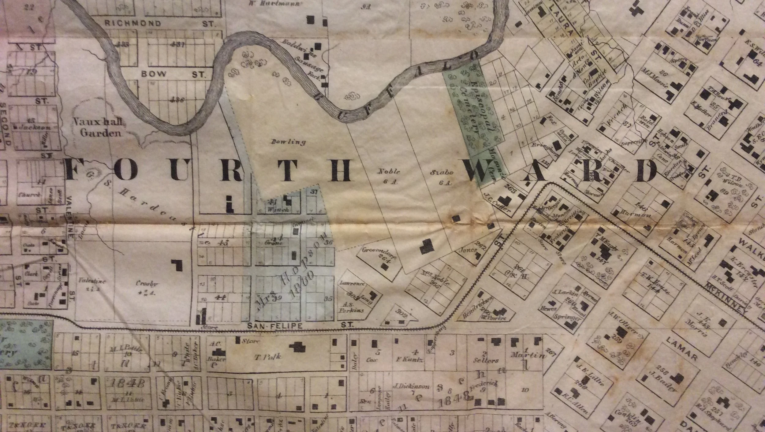
Mapping Houston: 1869

Historic maps tell us many interesting stories about the past. Tracing Houston’s history through an examination of its streets, bayous and buildings tells us as much about the diversity of people settling here as it does the geography. Historic maps often highlight subjects such as politics, land use, economics, transportation and patterns of settlement that change throughout the region’s history. One map in particular provides an amazing look at the City of Houston in 1869. Only a handful of these beautifully detailed maps still exist. The center portion of the roughly 5 foot x 5 foot map was drawn based on surveys by William E. Wood, Civil Engineer. It includes the outlines of hundreds of existing buildings and plots of land with the owner’s names. Like most maps, the names of the streets are included, but it also depicts the location of churches, brick yards, stables, hotels, and even cemeteries. Prominent city buildings like City Hall, Market House and the Court House are included along with the rail lines that cut through the city. Buffalo and White Oak Bayous are drawn in detail along with names of some businesses like Phoenix Iron Works and Baldwin’s Sausage Factory.
Shortly after the Allen brothers founded Houston in 1836, it was divided into political districts called "wards." The Five Wards of Houston are printed in bold lettering on the map. (Sixth Ward would be added later in 1876.) The ward system, a precursor to today's City Council districts, was a common method of organizing city government in the early 19th century. The lines were drawn along obvious boundaries including bayous and major streets and each ward elected two aldermen to the City Council. The city of Houston changed to a commission form of government just after the turn of the 20th century, thus making the wards no longer political boundaries.
A few separate smaller maps are included at corners of the 1869 map. At the bottom left is a railroad map of Texas complete with a “table of traveling distances” and the original plan of Houston is in top left corner, highlighting the importance of Buffalo Bayou to the city’s founding. A map of “new Houston,” a future addition to the city in the lower right includes Brays Bayou. The population was just 15,000 and total taxable value of real estate was $7,000,000. Despite the few statistics listed, there is no actual legend for the map. Several areas are colored yellow, pink or blue with no obvious explanation. Some of these maps are printed in black and white, so the color may have been added later by the owner of each map.
Adorning the edges of the map is a series of lithographs of notable buildings in Houston.They were drawn based on “views” or photographs taken by John Philip Blessing, a local photographer and business owner who moved to Texas in the 1850s. The views include Houston City Stables, Mrs. Brown’s Young Ladies Seminary, the residences of J.T.D. Wilson, A. Whiteker, and E.S. Perkins, the Eureka Mills, the Masonic Temple, Houston Gas Works, Allen Station, the Pillot Building, Perkin’s Corner, the Morris Building, Christ Church, the Old Capitol building, and Buffalo Bayou Draw-Bridge. The images were lithographed by William H. Rease of Philadelphia. He was a prolific lithographer of advertising prints in Philadelphia during the 1840s and 1850s and he was known for his inclusion of human details.
The best way to truly appreciate all of the details in this wonderful map is to see it in person. The 1869 Wood Map is on view in the Museum Gallery.